![The Ears of Rye Under Thy Sickle by Uladzimir Karatkievič [BLR]](https://gutenbergpublisher.eu/wp-content/uploads/2025/12/Kalasy_min-430x430.jpg)

Description
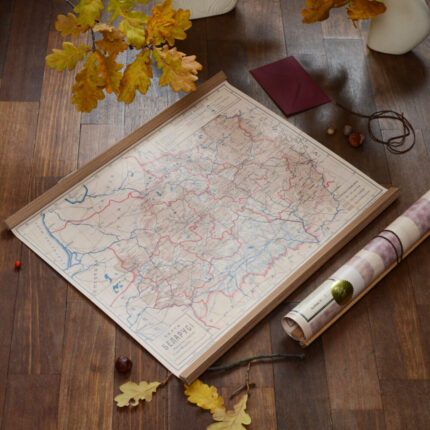
In front of you is a copy of Arkadz Smolič’s unique map of Belarus, acquired by the MALDZIS initiative in October 2025 in Poland thanks to funds from Belarusian donors: Dar’ji Sliž and Illi M.
It is the first Belarusian-language map of our country. It depicts Belarus within ethnic boundaries that corresponded to the then predominantly Belarusian inhabited territories. In addition, the map preserves the indigenous Belarusian wording of the names of geographical objects: Vilnia, Miensk, Horadnia (for cities), as well as Niameččyna (Germany) and Maskoŭščyna (Moscow) for countries.
The map was printed in 1919 at the lithographic workshop “N. Mac and Son” in Vilnius at a scale of 1:1,680,000.
The author of the map is considered to be the scientist, political and social activist, one of the founders of the BRL (Belarusian People’s Republic) and the first professor of geography in the BSSR – Arkadz Smolič. The map is physical and administrative in nature, which in many details corresponds to the textbook “Geography of Belarus”, published by Smolič in the spring of 1919 also in Vilnius.
The original map of Belarus by Arkadz Smolič has survived only in a few copies.
ABOUT MALDZIS
The initiative was named after Adam Maldzis, who sought and restored lost Belarusian values and names from oblivion. MALDZIS continues this work, seeing its mission in strengthening the image of Belarus as a European country and uniting Belarusians around national identity.


Reviews
There are no reviews yet.